The Okanagan Valley
can be roughly divided into two geographic sub-sections: the North
Okanagan (Map #2) and the South Okanagan (Map #3).
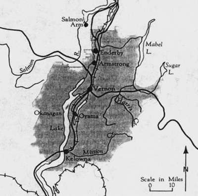
Map #2 - North Okanagan 1
The
North Okanagan includes the main trench of the Okanagan Valley
and its tributary valleys and adjacent uplands between Kelowna
and Enderby; however, the region is often considered to extend
as far north as Shuswap Lake - thereby incorporating the city
of Salmon Arm. Some of the major urban centres found in the region
are the Cities of Enderby, Armstrong, Vernon and Kelowna, the
Village of Lumby, and the District Municipalities of Spallumcheen
and Coldstream. As of 1971, about two-thirds of the total population
of 64,000 people in the North Okanagan lived in these incorporated
centres. Kelowna is the largest urban centre in the Valley, and
one of the largest within the whole interior of the province.
An important transportation hub (with trans-shipment rail facilities
and a major airport), Kelowna also had one of the more diversified
economies within the Valley in the early 1970s (the city supported
a strong tourist and recreation sector, lumber industry, truck
assembly plant, and major fruit packing, storage and processing
plants). Vernon, the second-largest urban centre in the north,
is located at the northern limit of fruit growing in the Okanagan.
Accordingly, other types of agricultural production such as dairying,
poultry, beef, and vegetables can be found around the city. Of
the remaining smaller centres, only Coldstream remained of any
consequence in the production of fruit by 1971. The economic base
of Armstrong, Enderby, Lumby, and Spallumcheen primarily relied
upon a combination of ranching and lumber.
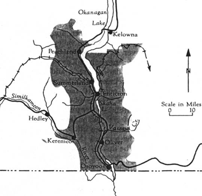
Map #3 - South Okanagan 2
The
South Okanagan-Similkameen covers the Similkameen Valley from
the Ashnola River to the 49th parallel, and the Okanagan Valley
from the 49th parallel to an area just north of Peachland. Some
of the major urban centres are the City of Penticton, the Villages
of Oliver and Osoyoos, Summerland, Keremeos, Naramata, Kaleden,
Okanagan Falls, Cawston and the District Municipalities of Summerland
and Peachland. As of 1971, over seventy percent of the total population
of 38,000 people in the South lived in these centres. Penticton,
as the largest centre in the south and the major commercial hub
for the area, was also a key packing, processing, and shipping
centre for the extensive soft-fruit and apple growing area of
the south. In 1971, about 2,500 acres of orchard still resided
within the city limits. Osoyoos, located two miles north of the
International Boundary, benefited from the development of the
South Okanagan Land Project, which brought irrigation to the local
benches and bottomlands. As with most other centres throughout
the south, fruit growing, packing, and processing are the backbone
of the local economy. The same could be said for Oliver, situated
twelve miles north of Osoyoos and designated as the service centre
for the Lands Project, as the village still supported large acreages
devoted to soft-fruit production in 1971.
___________________________________________________________________________
Footnotes:
*
The majority of this information has been derived from the information
booklet: British Columbia, Department of Land, Forests and Water
Resources, The Okanagan Bulletin Area - Bulletin Area No. 2
(revised). Victoria: Queen's Printer, 1974.
1. British Columbia, Department of Land,
Forests and Water Resources, The Okanagan Bulletin Area - Bulletin
Area No. 2 (revised). Victoria: Queen's Printer, 1974, p.
69.
2. Ibid., p. 61.
